February 26 – March 2, 2021

Many people we’ve met along the way have reported to us that Texas has a really low percentage of public to private land ownership. This fact impacts our travels as it becomes difficult to find camping spots other than private RV, state, and federal (national park) campgrounds and limits outdoor activities to those owning all the land. As I sat typing this blog entry, I decided to do a quick check of the facts and found the below link to information from 2013. In fact, Texas sits in the lower end of federal land ownership at 1.8%. Its place on the list is among other mid to late 19th century land grab states like Oklahoma, Nebraska, and Kansas, and the smaller New England states like Maine, Massachusetts, Rhode Island, New York, and Connecticut. The information is a little dated but I’m quite sure that big government hasn’t made any major land purchases in a while.
https://ballotpedia.org/Federal_land_ownership_by_state
I furthered my research to find out why public land ownership is so low in Texas but really didn’t find any sources worth quoting here. My guess is it has something to do with the land grants to incentivize settlers to come west after they ran the Native Americans on to reservations. I even found one discussion board comment suggesting that the state (Texas) had no money to purchase land and paid war veterans with land ownership. Any other ideas or thoughts are welcomed in the comments section.
The team was thinking about all this as we drove into the Texas mountain areas, seeing areas that would be great to explore but were owned by one large ranch or another. Combining this need to have what we aren’t allowed to have with the fact that it has been a while since we truly camped, dry camped with no hookups, we were really excited about being in Big Bend. A place seemingly at the end of the USA road, bordered by the Rio Grande River. A place were desert meets mountains meets different country. A place where history was rough and bloody, existing in a state of conflict for years before settling into the parameters of a country with law. But mostly, a place that is quiet with a dark night sky and ample opportunities to be outside in nature, a place to restore our souls and get us back where our journey began.
Travel Journal
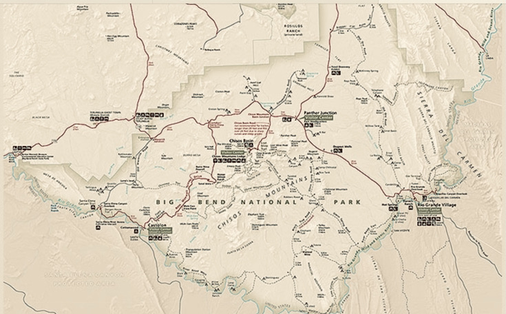
We left Alpine after an enjoyable experience and headed towards Big Bend National Park. Some locals told us that the most scenic drive into the park was from the town of Marathon, which was due east of Alpine thereby adding some travel time, but hey, we own time so what’s our hurry? Marathon was a zero stoplight town with a famous hotel that seemed quite nice based on our cursory pass. We hucked a right onto Highway 385 and headed south to Big Bend. The scenery was splendid with big mountain views of the Chisos range. Apparently, and according to the experts, this is the only National Park with a self contained mountain range within it, all of which were in view as we crossed on the federal land through the Persimmon Gap entrance of the national park. The small two lane road meandered along rolling hills with vast desert scenery all around. With the sunny skies, it all just seemed hot and barren. Although, really only a dry heat and temperatures in the mid 70’s but it was intense.


The first intersection that we came to was Panther Junction. A left turn takes you to the Rio Grand Village about 20 miles away in a south easterly direction and a right takes you toward Study Butte about 35 miles to the southwest. Our direction for the moment was towards Study Butte but not before stopping at one of only two gas stations in the park. As you might expect from our capitalist free market economy, the prices in this remote bend of Texas exceeded $3 per gallon but was a slight price to pay for the ability to move freely about the park. After filling the tank, something we’d do daily there, we headed in the direction of Study Butte then turned left onto Ross Maxwell Scenic Drive. This southerly drive would take us about 20 miles through some spectacular desert country, views of mountain range to the west and interesting land features all around. Near the end of the road we past the small historically significant outpost village of Castolon which has a rich agriculture and military history. (the link below provides some history of the community).
https://www.nps.gov/bibe/learn/historyculture/castolon_history.htm
About a half mile beyond Castolon we hucked a left into the Cottonwood Campground. The campground is one loop with a strategically determined number of sites closed due to COVID. All camp sites sit among tall cottonwood trees that provide a great place for many birds and birders. Several interesting birds that we’d see daily include the Vermillion Fly Catcher, horned owl, and a hoot owl that played chorus each night. Information on the campground reports packs of the Javelina that sweep the campground but we never had the opportunity to see any.
Javelina –
I asked one expert why they don’t simply call them pigs or hogs at which he responded that they aren’t pigs at all and are, in fact, more closely related to the hippopotamus than a pig. I’m not sure that “pork has salt” with me. So my research never confirmed or denied the hippo link but apparently the big difference in a pig, hog, bore and the javelinas is the javelinas evolved in the Americas where their doppelgänger cousins we mostly know as a pig descended from the European invasion. The javelinas are also smaller in size so you likely won’t see a young 4-H’r bulking one up for the blue ribbon prize at the county fair.
https://www.desertmuseum.org/kids/oz/long-fact-sheets/Javelina.php
Our campsite, No. 6, wasn’t all that shady compared to others but was fine for us. Each site comes with a picnic table, large metal bear container for food, and a pedestal grill. Other amenities include four pit toilets spread over two buildings, community potable and non potable water, and trash.


After setting up camp, we decided to make the short 8 mile drive to the Santa Elena Canyon to check it out. This drive is basically the end of the Ross Maxwell Scenic Drive. We got there with a few other cars in the parking lot. With Toohey doing his job of protecting the assets, we made the short mile hike into the canyon. The hike takes you along the Rio Grande as it enters the tall narrow rock canyon. The trail goes from the bank of the river, up and over a rock wall before descending into the actually canyon. There are several spots where you can walk down to the river and some even use this as a point to wade across the river to touch the Mexican canyon wall. We chose to take a few photos and head out. It was a stunning thing to see and definitely worth the experience. We were told that the trail does get crowded but crowds were light for our late afternoon stroll.

We left there and made a quick stop at the Santa Alena boat ramp so Toohey could have a drink. Dogs are only allowed where cars can go so as long as cars can back down a boat ramp then Toohey can legally have a sip.
We drove home in time for sunset and an awesome moon rise. The full moon was spectacular as it came up along side the Cerro Castellan peak which overlooked our campground. The peak sits at a height of 3,293 feet and from the rivers edge appears huge. The scene was spectacular and left us with some major excitement about what was to come.
“Happiness is to be outside, to walk, to look, to amalgamate with things. Sitting down, you fall victim to the worst of yourself. Man was not created to be nailed to a chair. But perhaps he doesn’t deserve any better.”
Emil Cioran


Meditations of a Desert Trail Run
Moving through the arid desert air, flowing easily up and down the hills, through arroyos, stepping up and down rocky ledges, following stone cairns as the trail disappears into a dry wash only to return on the other side. Considering briefly the mystery of how my feet somehow and without thought, land balanced on earth, a surface covered in loose unstable rocks. For the moment, my ankles consisting of bones and soft tissue remain intact, allowing me to continue my desert muse. This befuddling mystery likely lies somewhere deep in the brains ability to use all the senses without thought, letting the body flow, working best when less focus is given to the each task, instead, allowing sight, sounds, and smell to capture the inspiration around me.
The land, seemingly desolate, motionless, provides a dichotomy of sorts to its natural beauty. Not the spectacular views of the grand mountain summits of the west, but a view requiring more focus on details, an appreciation for the hardy life thriving in the desert environment. At first glance, little life can be seen, a place with little moisture providing a contradiction to its lushness, green with living foliage. Hues of colors, greens, purples, pinks, browns, and rust spatter the landscape in all directions. Sounds beyond the quiet buzz of silence were those of my shoes impacting with the ground, me breathing, and on one occasion, a small bird thrashing about in the thicket and the surprising light trickle of water near a moist desert spring.
Thoughts drift from being in this moment of time and space to a brain wandering through current events, unsolvable problems that become more clear, or conversations I should have had but lacked the words that I now find easily while in my aerobic stupor. Remembering to stay grounded in the presence of the run, bringing back the quiet surroundings, the beauty of the desert trail. At times I stop completely to take in the views from afar, seeing the landscapes of weathered rocks given names like “mule ears,” natural earthly structures used by those before me for directions to subsist in this place. Drawing my vision closer to the land around me of cactus and scrub brush until I am looking again up close at the desert environment, the beautifully placed minuscule details in this dry barren land beneath me. All of it creating a peaceful feeling, a wasteland to some, but remarkable to me.
Later I apply names to the colorful things to include prickly pear (greens, purples, pinks), the tall proud Spanish daggers with some standing over 16 feet, sotol, and others we don’t know by name, some with nasty thorns while others provided resources for ancient inhabitants. The scanty foliage creating obstacles to me as I flowed along the trail also provide slight cooling shade to venomous snakes, scorpions, and tarantulas, seemingly all the devil’s work here in the desert. The preferred startled view of a mountain lion, coyote, javelina, and bear would be welcomed, at a distance of course, but they never appear.
It is the continued lure of the trail itself though that brings the greatest threat. The hypnotic danger as you advance with the next turn, hill, summit, the prospect of a view unseen that is just too close for me to stop my forward motion. All the while becoming numb to the body’s fatigue, hydration, the time needed to return safely, and more, the ability to make clear decisions of the day. This mindful meditative feeling is the drug of choice that fills my veins with the danger of not being aware, one that keeps me advancing in a mindful trance through this parched, banal, wasteland, forgoing thoughts of time and distance, safety, the limits of food and water. These are the true hazards of the trail.
Our run out past Mule Ears Springs, along Smokey Creek Trail was stunning, nectar for our souls, reminding us both of the special place we were existing. Gorging our senses with as much quiet nature until our cores were filled with the experience, one where stopping and turning back was the most unpleasant necessary option. The trail gave, and continued to give a consistent squeeze of the emotion, fervor for the soul.
The End
We got back to the truck where we left it sitting in the empty parking lot. We relieved the pooch of his duties of protecting the assets while enjoying a nice tailgate breakfast of hard boiled eggs and leftover luke warm coffee from the insulated French press. We sat silent and low on the concrete curb with our view back out into the vastness of the desert landscape we just ran, enjoying the silence, constantly searching for some movement, life, color, or object we’d missed along the way. Toohey sniffed about off leash yet close by as we could hear any approaching vehicles coming along the long drive back to the trailhead. The morning run provided a feeling of calm over the team mixed in with some excitement of the remaining possibilities of this vast beautiful place.


As we left the trail head, we made a few other stops at overlooks. We saw what we first thought were big horn sheep darting through the brush but upon further research determined they were aoudads, or barbary sheep, an evasive animal introduced by ranchers for exotic game hunting much like other weird animals we’ve seen around the state. They have controlled shoots from helicopters to remove these animals as their existence is apparently a threat to the health of the desert big horn sheep population.


Big Bend is connected by long stretches of two lane roads that do a sort of semi circle around Mt Chisos. There is one road that takes you high into the Chisos Basin. The basin is a remarkably different environment from the desert that surrounds it, more high mountain terrain than desert and more National Parky busy with a large campground, store, visitor center supporting more of the big mountain hikes. This basin wasn’t a part of our afternoon plans so we jetted passed this entrance and continued north through the park to the Rio Grande Village, Boquillas Canyon Overlook and the Rio Grande River along the eastern end of the park.


The Rio Grande Village was a small outpost with camp store, small visitor center, gas, and a campground. We did a quick look and turned back towards Boquillas Canyon. The turn for this was just prior to the village. Along the way we passed the Mexican border crossing to the town of Boquillas Del Carmen. This small town has played host to many park goers pre 911 and COVID but now sits behind a small gate and bridge. We were told that in years past visitors would make the boarder crossing for Mexican food and drink, donkey rides along the Mexican side, and other adventures. As things stand now the gates are closed but the ingenuity of the Mexican capitalistic spirit remains. The Mexicans come over to the US and leave trinkets, seemingly handmade but likely not, at least they aren’t made in China. Likely with a nickel of production cost, the least expensive items are $10, and include painted walking sticks and wire with colorful bead work shaped to resemble cactus and road runners. We chose the peacock and a walking stick. We paid US currency by placing the money in a plastic bottle with its top cut off. In our mind, it is really just a small contribution to support hard working humans separated by 10-yards of slow moving water, who like us, have to deal with the borderless virus that has impacted the world. We would later discuss this with a Park Ranger, the kind of ranger with a gun and bulletproof vest, who agreed it was no big deal. Then even later we would read in the park magazine that this is illegal and considered illegal contraband.


After purchasing the goods at the overlook pull off, we stopped and watched as Mexican cowboys on the other side of the river were mostly just sitting there. One was out on his horse doing his cowboy thing. We drove out and down to another parking lot and took short hike over to the Boquillos Canyon Trail. This was a quick up and down over a rocky chunk then along the river. As we approached the river we saw a Mexican Cowboy riding across the trail apparently working his display of goods, exactly the same kind of gifts we had just purchased at the overlook. He approached us on the other side of the display along some short trees while still on horse back. He was dressed with cowboy hat on top, mirrored aviator gold rim sunglasses beneath and a big smile tucked into his bushy black mustache. He said, “Hello amigos, would you like to buy something?” We said we had already spent our money at the overlook at which he appeared disappointed. We asked if they weren’t all the same and he said, “no.” He then pulled a clear package from his saddle bag and while holding it up for us to observe started his sales pitch, “How about 6 hot tamales for $10 – are you hungry amigos?” We didn’t purchase the tamales but found the experience curious.
Along the trail we’d find another four of these retail set ups, minus the Mexican clerk on horseback, and even a note in large black letters painted on a rock offering a Singing Jesus in the Boat for $10. There were Mexicans sitting all along the shore, one in a canoe offering rides to Mexico to another couple, and some just sitting there waiting to cross the river to gather their daily contribution to their countries GNP. On the US side were a couple of sun bathers and a few young ladies braving the slow moving current to wade across the rock-bottomed shin-deep water to the Mexican shore for a photo opportunity. Looking southeast from the end of the walk, the water flowed into the high cliff walls of the canyon and disappeared around the first bend. With the day heating up, we turned, walked the water,s edge out, past all the vendors, over the rock to the parking lot where our dutiful pooch was resting comfortably protecting the assets.


The evening was spent back at basecamp sitting in the nice comfortable dry air. We met our neighbor who has been traveling fulltime in his Ford Focus with a small tent. He is a young man, maybe 30, who lost his job in Seattle during the COVID thing and decided to fly home to Alaska to retrieve his car, drive back to the states, and has been traveling around seeing the country and developing a business plan involving his travel. He seemed to appreciate the simple joy of being away from people, the rush, and the news and finding adventure wherever he goes. We’d spend time in short conversations mostly about trails we’ve experienced in Big Bend.
Lysette had done her research and had a day two trail run queued up. This one was called Cattail Falls, was a trail not on the park map, and took us up to the base of the Chisos Mountains to a desert, spring fed, waterfall. As with the previous day, we left before sun up to beat others and to meet the rising sun. It also assures us of cooler temperatures for Toohey who stayed behind to protect the assets. The first two miles were through the desert, a more grassy desert scene than Mule Ears, along a closed gravel and rock road. We flowed up and down a few watersheds before coming to the right turn at the intersection. At the intersection was a huge old cotton wood tree providing shade. A left turn would take you to the famous Window but we were planning to do that hike later in the week. We turned right and from there, the trail climbed up and over an area resembling a North Table Run in Golden with brown rocks, rock outcroppings, and scrub brush. Then the trail dropped down into a narrowing canyon sitting up against the rock faces of the Chisos Mountains. At the very end of the canyon was a flow of water dropping about 50 feet, an amazing sight to see in such an arid place. It is a neat thing to see an oasis of sorts with fresh water bringing the beauty of life in the middle of a desert. We only saw a few birds but can imagine the wildlife and foliage that this place supports. We maneuvered around large boulders, smoothed either by large rushing water or that of other humans squirming their way here. We made our way to the end, standing at the pool below the waterfall and looking up the wall watching the water flow over, curve and fall a few feet in front of me. With a cupped hand, I reached into the pool to capture some water, splashed it on my face and head, bringing to my mind the thought that a Native American, vaquero, or cowboy had likely done the same many times and years before me. Our run back was more of the same. We returned to Toohey who was sleeping comfortably in the cab, cooled by the still overcast skies and brisk morning temperatures helping make this experience all possible.


Our curiosity of the hike, where we had just gone in relationship to the place called the Window, a main attraction of the park, has had us in long conversations ever since arriving. As we left the hike, we made several stops with binoculars trying to locate where we had run in relation to this feature. We were also quite perplexed by the thought of another 2 miles along that trail to the Window as the elevation gain and cliffs seemed unlikely. With tired legs and the need to know, we made the decision to drive to the Chisos Basin to see what all the fuss was about. This was something we had budgeted for the next day, Monday, but we couldn’t resist knowing and with the entire day still ahead of us, we set off. The turn up into the basin is signed as a curvy slow mountain drive. As we gained in elevation the topography became extremely interesting as we began seeing pine trees and more arid high alpine look than the desert terrain we’ve been enjoying. The drive takes you over a pass and then drop into the basin. The basin, an area that sits low inside and surrounded by mountain peaks. Pretty cool with thoughts of why did we wait this long to come in here. We pulled into the parking lot which was big and packed making us now realize why we didn’t. It was full but not “major NP” full. There were many longer hikes leading from here and yes, the Window hike and overlook trail.
Before exploring it further we had boiled eggs on the tailgate and walked Toohey. Following that we set off to see the Windows overlook and understand what all the fuss is about. It was a spectacular view and answered many of the questions that we had about it. Mostly that the window isn’t a high arch or eroded box cut from the wear and tear of time but more a valley with views of the area we had been exploring. The basin itself was formed by volcanic activity that once subsided left the large crater or basin that is now a spectacular place to see. Information at the part related the formation to what occurred with Mt St. Helens in WA. With the information now in the books, we decided to make the drive back out of the basin and home.


Along the way, we stopped at several trailheads to scope out ideas for tomorrows run and hike. We looked over observation points at gullies and played witness to more of the interesting landscapes that make this place fun.


We headed home to camp exhausted for the two days and the need to relax and take in some calories. We talked to other campers and watched as cars pulled into the campground stopping at the picnic area. The occupants appeared to be people coming in search of birds as this place, with its large cotton woods with water access, is perfect for migratory birds of all colors. At one point, Lysette commenting on how much she likes that I am also a birder which is funny as she is the one who seeks out the birds to photograph and label. As nerdy as being a birder might sound too some, we both agree we are a fanny pack away from falling into the category of people as we do both enjoy seeing and capturing various birds just as we do all wildlife.
As a group of four people with binoculars strapped to the neck walked past our camp, they commented on our A-Liner with each couple saying they had one at home. We continued the conversation eventually learning that two of them were park volunteers with a permanent home in Wisconsin. They went on to provide several off map hikes that we should do in the area, even marking them on our map so we could easily find them. A bit of travel gold information.
Later that evening we did a short drive and short hike up to some ruins. One of which was a partial shell of a house with the fire place remaining. The fire place was made from petrified wood pieces and is still standing proud and strong. The volunteer ranger who told us of this hike also said it was featured in Barbarosa, a cowboy western featuring Willie Nelson. We enjoyed exploring these ruins as the sun started setting in the big desert sky. We made our way home to relax into the evening, watching as all the campers turned from lively humans to a series of head lamps then to quiet darkness. The sleeping temperatures started off warm but we woke to windy and cool and the slow start the team needed.


The previous night while we were sitting outside, a fellow camper came up and asked if she could see inside our A-Liner the next morning as she’s been interested in something like that. She was camping with two men who were in small tents and she was sleeping with her small pooch in the back of her 4Runner. The next morning, after breakfast she and her mates came over for a look. The conversation expanded from the camper to a lot of other interesting stuff. We’d learn that she is a plein air painter and sculptor, while one of the other dudes in her camp is the author and of books about the west and was currently here on a work trip to update his book, Falcon Guide: Hiking Big Bend National Park. So here we were standing among two hugely creative humans who were also well known inside the park for their work. They were fun to converse with, excited to share what they knew about this wonderful place, and they provided some insight into their favorite hikes, and what they were up to while in the park. Both were on a working trip here, her to paint and him to update his trails and book photographs. Oh, he is a photographer too. I have provided links to both of their websites below so you can see for yourself the amazingly creative and knowledgeable humans with whom we were hobnobbing.
We left them and made the short drive to the Upper Burro Trail for our featured hike for the day. Our young neighbor at camp had done this hike and remarked on it being a good one that followed a wash into narrow canyons. We parked the truck at the trailhead with the sun to the rear blocking the cab to help keep shade for Toohey’s work protecting the assets, then set off down the trail.
The trail descends the entire route through the wash and, as mentioned, into a low canyon which narrows as you advance. There is one small natural window or if you were in Utah, an arch. The rock, unlike Utah is chocolate brown and ragged, almost at right angles in places making it appear brittle. The rocks, in contrast along the river bed, were worn smooth from water flow with some grayish blue and red hues. The smaller stone and gravel between provide a cushy landing with each stride. There were some places along the trail where the drop is more technical requiring a three touch plant for balance to squeeze or slide off short drops to the surface below and a couple where the drop required a stop to route find or locate rock cairns or other mark for the easiest and safest passage. When we reached the end of the trail there was a 20 foot drop, or what we learned is referred to as a pour. This is where the water funnels down to the next level, usually a significant drop. These being smooth and gray to the surrounding brown rock almost like a spout in some cases. We stopped and asked the couple at the bottom which side of the 5 foot wide area they descended as neither looked all that appealing, and they confirmed where we were starting our attempt was where they descended. The descent required all appendages, body weight on my butt, and some cracks to brace against for leverage before the final drop. Lysette followed and we found ourselves standing in a small dome of a rock with a slight view of the sky above. The normal flow of this dry river bed went out of a window and down another pour to the left which dropped well over 100 feet with no possible advancement without ropes and harness and good luck. The end of the line for team TWT.
We stood and enjoyed the moment, yelling down to someone who had hiked in from the bottom but I forgot what we said so we’ll leave it at a yell. We turned back following the same route up the pour with Lysette leading the way. The run back to the truck was uphill the entire way and along with the warming sun, wind blocked from the walls of the wash, required a bit more effort.


Based on our excitement of this trail and more, the abrupt ending to it, we decided to drive around to the lower trail to see what it looked like from below on the other side. This required a short drive ending in a looped parking lot. The hike back was a half mile along the river bed with views from below confirming we would have died had we attempted to descend it. The exit actually undercuts the ledge with no route down. The worn rock along the pour was so significant that it has actually made a semi cylinder shape of smooth rock like a funnel. At the bottom is a deep waterless pool covered with dry pebbles. As you stand there you can’t help but imagine what witnessing a full flow of water through here must look like.


We left this area after taking Toohey on a short hike around the roads which is legal in the National Park. We gave him plenty of water and a few more cookies before setting off for our next short adventure. We were looking for the Mile Marker 18 arroyo that the birding couple yesterday said we should hike. We found the gravel pull off, positioned the truck and Toohey to maximize his shade for his comfort, and set off. We crossed the road, found a break in the brush, then dropped down off the low brittle edge into the wash. The hike is basically to follow the dry river bed into a canyon. We quickly spotted several healthy lupines standing tall with their purple stalks of flowers in full spring bloom. The rocks and river bed were similar to the Upper Burro trail as were the canyon walls. We spotted several small water holes and then finally approached the narrowest part of the canyon with a water expanding the entire width and deep enough to require getting muddy and wet if we chose to pass. We opted to turn back and hike out the same way we entered greatly enjoying the experience.


On our way back, we pulled into the small village of Castolon to read history about the farming and military past. We talked to a volunteer ranger and then grabbed a few provisions from the small store, then headed to camp. Big winds kicked up during the late afternoon that eventually pushed us inside the camper for the evening.
Our last morning was a cold one, we ate a breakfast, packed it, loaded it, and hitched it. We spent some time talking to other campers and saying goodbye to our new friends we met during our short stay. We made the decision to stop at the Burro Springs Trail for a short final run in the park. The pull off was long allowing for our rig to easily fit. There were two other cars there, one of which was our artist friend from camp. We passed her and her pooch along the way sharing a brief conversation. The trail followed the base of a mountain around to the backside. The slope of the mountain to our left turned into rock cliffs with the opposite sloping down to the drainage. The final switchback on the trail dropped us down to a basin where there was a 5 foot pour to the uphill side and a larger pour dropping a 100 feet of so to the water and spring below. We marveled at all this before turning back along the trail. We finished the run with our artist friend painting in the parking lot. Being nosey, I asked and she gladly showed us what she was working on, a small piece she said she was going to give to a volunteer ranger who allowed her to camp the other night even though there wasn’t a spot. A really nice gesture given her talent, a gift that I am sure will please this person to no end.


Our time in the park was awesome and is a national park we’d definitely recommend for a fall, winter or early spring excursion. This national park wasn’t crowded allowing for lots of time and space to enjoy the silent beauty of the wildness. The place offers lots of opportunities to hike both mountainous and desert environments. We would plan our next trip here with time in each campground and would definitely plan more time hiking the Chisos Basin with its higher elevation trails. For a longer dogless experience, there is the 34 mile Outer Loop that would give a few nights under the stars backpacking style experience, capturing the desert and high Chisos mountains in one big experience. Besides the three main campgrounds, there are many gravel roads throughout the park, many requiring four wheel drive and some high clearance vehicles that are scattered with permit required wilderness camping spots. And then there is the whole Big Bend State Park which deserves a look. From what we heard, this place is more remote and rugged without the high Chisos Mountain range, but definitely a must do. There is so much more to this place of which our glancing blow just nicked the surface, definitely requiring a return visit for a longer stay.

We drove out of the park through Study Butte, Terlingua, Lajitas, and along the most southern US road, Highway 170. This road cuts through Big Bend State Park, hugs the Rio Grande, separating the views of majestic Mexico landscape to the south. This road was spectacular with short steep hills, quick curves, and views of the surrounding two countries landscapes. It also provided us a glimpse into what the state park has to offer, an offering that we’d certainly give a chance on our next trip south.
As an update to our current position, we are in Golden taking a three week hiatus from the road while living in a friends basement apartment. The truck and the team have all received maintenance, our taxes completed, and the trailer, our home remains in the shop. We plan to remain here through the end of March then set off in a southwesterly direction with 3 nights reserved at the south rim of the Grand Canyon mid April. We are studying the availability of COVID vaccines and are hoping to find a strategically convenient place to start this process as soon as possible. Stay tuned for what actually happens.
Comments
One response to “Texas Episode 6: Big Bend National Forest”
My nightstand read, thanks for sharing your adventures…so envious